Weekend Break: Maintaining the jetties
Published 1:00 pm Friday, December 29, 2023
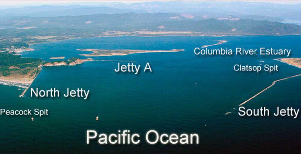
- An overview of the jetties on both sides of the Columbia, which help to make the mouth of the river more navigable for mariners.
The Columbia River Bar is a notoriously dangerous place to navigate.
Its constantly shifting sandbars and unpredictable currents were treacherous for European Americans attempting to cross in the 18th and 19th centuries without expert Indigenous pilots.
The navigation channel would change so often that mariners’ charts from just a couple of years earlier would be outdated. The maritime community pleaded with lawmakers to help fund a solution to the problem.
In 1882, the River and Harbor Act authorized a team of engineers to begin the process. Early plans were for a single jetty on the Oregon side of the river.
In the 10 years of initial construction — what the U.S. Army Corps of Engineers referred to as phase one — more than 940,000 tons of rock were laid down.
While there are several types of jetties around the world, the mouth of the Columbia has rubble-mound training jetties. The jetties’ great piles of rocks create a more predictable, naturally dredged navigation channel by training the river’s current to flow in a particular direction.
Changes in the channel were almost immediately noticeable upon the jetties’ construction. In 1889, the channel was about 20 feet deep. By 1895, that had increased to 31 feet.
Those gains began to decrease in the late 1890s, however, and the Army Corps began new projects to extend the South Jetty and construct a North Jetty on the Washington state side of the river.
By 1917, both the North Jetty and the South Jetty’s phase two had been completed. The Army Corps of Engineers’ dream of a 40-foot-deep channel was being realized.
Their vision adjusted slightly when engineers realized how much the base of the North Jetty was eroding in just the first decade it was built. Jetty A, which extends into the river from the Long Beach Peninsula, was constructed in the 1930s to create a buffer for the main structures.
Nearly 55 years and more than 9 million tons of rock later, the jetty system at the mouth of the Columbia River was complete. The official navigation channel is about half a mile wide and extends for 6 miles, connecting the Columbia River to the Pacific Ocean.
Looking at maps from the early 19th century to now, it’s clear how much the jetties have affected the shape of the Columbia River’s entrance.
The shores on both sides of the river are dramatically built out from their original positions in the 1860s. Where previously it was a gamble for mariners to successfully anticipate Clatsop and Peacock Spits, now they can reliably and safely do so.
Keeping the navigation channel consistent is essential to both the regional and national economies.
According to the U.S. Army Corps of Engineers, Portland District, seaport activity in the lower Columbia generates more than $200 million in state and local tax revenue and contributes 10% toward the state of Oregon’s gross product.
Structures of this size in an environment this unforgiving require careful maintenance to ensure their survival.
Since 2016, the Army Corps has been restoring the jetties to their former glory. Jetty A and the North Jetty have been properly rehabilitated. The South Jetty is anticipated to be completed by 2025.
At over 6 miles long, it is the largest of the jetties and its reconstruction was significantly hampered by pandemic-related delays.


-
eEdition

-

-

