The Monthly Stack: Beards Hollow, Pt. 1
Published 9:00 am Wednesday, March 29, 2023
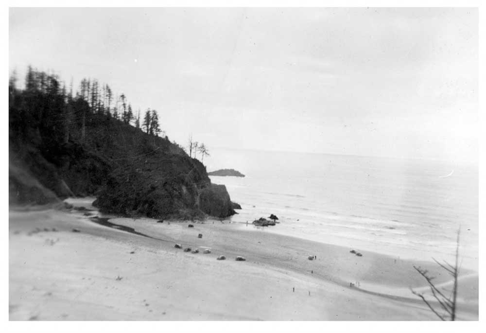
- The shoreline at Beards Hollow has receded hundreds of feet since the construction of jetties at the mouth of the Columbia River. Forest and wetland areas now cover much of the sandy shore seen in this image.
In few places would it make sense to stumble onto a tall, mountainous island on a trail of wetland grasses and shore pines.
For clues as to how the sea stacks of Beards Hollow, the cove just beyond North Head Lighthouse toward Seaview, Washington, came to rest far from the shore, look to the coastline as it appeared a few generations ago.
The black-and-white images on interpretive signs above the cove are enough to invite a double take, a look toward the headlands and back again. Before the construction of jetties at the mouth of the Columbia River, sand and ocean reached hundreds of feet beyond the present high tide line, forming a cove and driftwood-covered beach.
Much of what now makes up a wetland habitat, accessible by trail, was in recent memory underwater. Rocks that once housed tide pools, places where people might forage for shells and seafood, are now hidden behind growing forestland. Beach grasses brought to the area have added a new dimension to the landscape.
To get a reference point of the changing coastline, look to some of the cove’s identifiable sea stacks. There’s O’Donnell Rock, also called O’Donnell Island, Harp Rock and a collection of outcrops often called the Fishing Rocks.
Take a book out to the beach on a sunny day and you’re likely to find plenty of fishermen, casting lines in the afternoon light as they stand in places where fish once outnumbered people.